Chapter 10:
Communications and Boundary Stones
Communications
At this point we must consider the means of communication from Gilling to the neighbouring villages and such places as York. The communications between York and Gilling, and Gilling and Oswaldkirk, seem to have had little mention in the Gilling records. There was a means of getting from Sheriff Hutton to Gilling in 1651, but not by a carriage road. In that year the way was described as a “highway”, but in 1652 it was a “common lane”. Apparently it left the York to Sutton on the Forest road, and ran north-east between Marton and Farlington. It was in great disrepair in that period, and it was inferred that the road through Stearsby and Grimston to Gilling was a bridle road. Confirmation of this was found in the diary of the Earl of Rutland (the Manners family) who had property in the Helmsley area. He states that:
“the saam day (April 29th) I with Lord
Pawlett and Sir Ralph Hopton came to Helmsley, leaving
Sheriff Hutton Castell a halph mile on the right hand
and cam to Gilling, the Lord Fairfax. A highway from
York to Huntington and thence to Kirbymoorside via
Sheriff Hutton and Hovingham.”
In 1688, 20th May, articles of agreement betwixt Charles, Lord Viscount Fairfax and Fewster of Wasse, for the building of a stone bridge over Holdbeck upon the greene of Gilling to have to be for cart and carriage. The said bridge 4 yards within the battlements. The battlements to be 2 feet high of free stone and well wrought. The said bridge to have a sufficient arch the length to be 5 yards. The said battlement to be caped with free stone and a foot high. The said Fewster to lay in security for keeping in sufficient repair for 7 years after the finishing of the said bridge and to lay in good security to said Lord Fairfax and then the said Fewster to receive 18 pounds of good and lawful money for the workmanshipe of the said bridge in full the money to be paid him by Edward Jackson of Gilling. The bridge over the Holbeck has three small flood arches a little distance away. Also called Holbeck 1688, gratuity April at Thirsk towards building stone bridge over Holbeck nigh Gilling £20.
“In 1768 the Oswaldkirk Turnpike Road
was established. An Act of Parliament was presented for
amending and widening the road from the City of York to
the top of Oswaldkirk Bank, and from the said road in
Sutton field through Crayke towards Oulston, the extent
of the Lordship of Crayke.”
The Lord Fairfax was one of the chief advocates. He considered that people would gain. He would gain by quicker and better access fron his seat at Gilling to York, and as he explained to Lord Fauconberg in a letter dated 28th February 1767, by creating a turnpike road there would be less danger to life and limb for the inhabitants of the area. He failed to get the support of Lord Fauconberg in spite of promises of a link road to Coxwold. However, Fairfax invested £700. The road was made 4 yards wide. In the 18th century the roads in the Howardian Hills were stated to be too narrow and steep at the sides, and were very rough as the stones were not sufficiently broken.
Special mention is made of the placing of an extra tollgate in 1831
“across the road in the township of
Gilling at the point where the road leading to Coulton
branches from the said road, also a tollgate on the side of the said turnpike road, upon the road leading to Coulton.”
This side bar at Coulton was one of three erected on side roads adjoining the turnpike, at which prescribed tolls were taken, the passengers approaching the road in this way being allowed through the next gate on the turnpike without charge.
The villages through which the road passed had to supply labour for the maintenance of the road. On 13th June 1768 Gilling had to supply 3 days statute work. On 15th July 1768 Grimston had to supply similar labour for work on the road over Grimston Moor, and on 20th April 1769 Clifton, Wigginton, Sutton, Stillington, Marton Lordship, Brandsby, Gilling and Cawton had to supply 3 days work for each township, presumably for their own section of the road.
In 1772 milestones were erected from York to Oswaldkirk, and if Mr Duncombe’s permission was given, on to Helmsley. The mile “stones” were to be in the form of wooden posts 4½ feet in height. Every third mile there was to be a horsing stone, i.e. for mounting horses, etc. Directions to York and Helmsley were put on each post and stone. Three of the horse stones survive, the first near Wigginton [I cannot find this stone; but there is one about a mile north of Sutton. G.S.], the second in Gilling village, and the third at Golden Square between Oswaldkirk Bank Top and Helmsley. They are formed in the shape of a step. The Gilling stone is marked “York 18 miles”. If they were every three miles, then there should be one somewhere near Brandsby, and one three miles from York [this may be the one “near Wigginton” noted above]. These have disappeared.
Most of the turnpike roads were soon in debt, and by 1800 the roads and bridges were taken over by the North Riding County Council and the roads became a charge on the rates.
Boundary stones
Prior to 1796 there was a dispute between Mr Charles Gregory Pigott Fairfax and Lord Fauconberg regarding the definition of a boundary between their estates, and the following boundary was perambulated and fixed by stones set in the ground.
“Starting at Osborne Corner [near Laverick’s Engineers] where the manors of Yearsley, Gilling, Brandsby and Grimston meet, and where there is a new stone placed marked Y&G.
North west in a straight line to the north side of Malton Road near Yearsley New Enclosure Corner another new stone “the centre part of this line being exactly 12 yards south of the Old road”.
North west nearly in a straight line to the base of a large mount of earth called South Coney Hill...thence to a stone called the Weapontake stone which divides the wapentakes of Birdforth and Ryedale and which is marked with a cross on its top and is situate near the road from Yearsley to Gilling.
Thence to Whinny Cross Hill where an earth fast stone is marked with two crosses and a new Y.G. stone.
Hence nearly in a straight line across a gill...to Callinger Rigg...earth fast stone marked X and a new Y.G. stone...
Then in a straight line to Old Quarry Hill...earth fast stone marked X and in a str line to Windygate...new Y.G. stone set between two earth fast stones each marked X.
Thence nearly in a straight line across a Gill to earth fast stone marked X on Nettlebed Hill near Shepherds Hut...a new Y.G. stone.
Thence to earth fast stone marked X at 33 yards from
the south extremity of the fence wall of the new Inclosure made by the late Lord Fairfaxe adjoining a new Y.G.stone...north by wall to the beck which divides the township of Yearsley from Thorpe Grange, along which line are two old stones marked and two more recent Bounder Stones hewn to an octagon, the last of which is set at the north end of the wall adjoining the beck.”
In 1976/7 on several occasions I tried to find these boundary stones; I was assisted at various times by Trevor Robinson and George Stabler of Gilling, and finally by Raymond Hayes of Hutton-le-hole. The following is a record of what we found.
- Stone No 1.
- This was recorded as being at Osborne Corner. This turned out to be in the SE corner of the field in which the Long Barrow stands. It stands in the break in the wall (part ruined). The stone has Y and G on it, and the date 1786 which does not tally with the date on the document describing the boundary. There is no cross on the top. The position of the stone is at 6028 7395.
- Stone No 2.
- This stone is on the north side of the Malton-Yearsley road. It is virtually in the grass verge of the road, 8ft north of the road metalling. This one is octagonal or perhaps square with chamfered corners. It carries a Y.G. mark, and there is an Ordnance Survey broad arrow (benchmark). The O.S. position is 6000 7425. This is in line with the hedge and wall leading to the first stone. There are now two round barrows: a northerly one, the better preserved, lies nearer to Coney Hill Farm; the second round barrow, to the south, is nearly ploughed out but is still visible. Just to the south of this latter hill in the setting sunlight we could see a distinct flat ridge. A little south of this ridge or terrace there could be seen a distinct green line where the weeds grew more profusely. This pointed straight at the long barrow. Is this the Old Road? There was no definite increase of scattered stone in the area, but we found one piece of green glaze ware (Cistercian). The boundary record states “south of the Old road”. This keeps it on the parish boundary throughout.
- Stone No 3.
- This is described in the record as the weapontake stone, which divides the wapontakes of Birdforth and Ryedale. There is no evidence of the position of this marker, but I consider that it was likely to have been placed on the parish boundary. There is a kink in the boundary line between the two wapontakes just south of the large barrow, and about 100 yards in from Cooper’s Lane. I reckon that the stone should be at the point of the kink. It has no doubt been removed as it would be a hindrance to ploughing. A search among the stones lying on the summit of the barrow may reveal the stone as it had a cross marked on it.
- Stone No 4.
- The boundary continues undistinguished across the ploughed field to an elbow in the wood. The stone wall starts near a large alder tree on the corner. The wall continues on the NE side of the track and goes up Whinney Cross Hill (White Cross Hill). Here a new stone was placed marked Y.G. and there was an earth fast stone, marked with a double cross. We searched on the NE side of the track and failed to find anything, then suddenly to the SW saw a large well placed octagonal stone about 2ft by 2ft marked as stated in the record. By its side was a large moss-covered stone which when cleared revealed the required markings, rather like the cross of Lorraine. The new stone is mounted on a square plinth. Strangely the stone is not set on the summit of the ridge but a little to the NW, at 5922 7479. The existing wall is then not the boundary at this point.
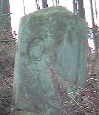
The G marking on the stone |
Two views of this stone, showing the G and Y markings on oppposite faces. The adjacent earthfast stone was overgrown and not visible when these photos were taken (March 14th 2000).
Photos © Gill Smith 2000 |
The Y marking on the stone |
- Stone No 5.
- (Calliger Rigg). Following the line established we descended the next valley to Calliger Slack and then up Calliger Rigg where the next stone should be. Here there should be a new stone marked Y.G. and an earth fast stone marked with a cross. Raymond Hayes and I did some excavating on what we thought would be the line but failed to find any stones.
- Stone No 6.
- (Old Quarry Hill). Here nothing was visible although a good search was made.
- Stone No 7.
- Wyndygate. This presented a bit of a problem. It is certainly not Wyndygate Farm (now known as Yearsley Moor Farm), it being too far to the NE. It must indicate the gate on the drive up to it. Is this on Newton Hill where two tracks from Wyndygate Farm meet the main carriage way? Here there should be a new stone marked Y.G. set between two earth fast stones marked with a cross. Is Newton Hill a corruption of Newstone Hill? We searched here and found nothing. It was difficult to decide whether we were on the line. We uncovered several huge stones in the bank side.
- Stone No 8.
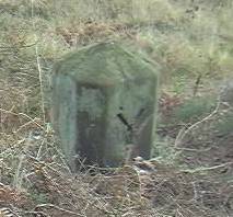
- Nettlebed Hill near Shepherds Hut. Is this now Shepherds Hill or Rigg? There was no evidence of a stone or the Shepherds Hut. We eventually found the stone on Shepherd’s Rigg near a clearing in the wood after following the wall from the Wyndygate road. It is set in a stone wall about two feet high, and is similar in size to No 4. Its position is 5840 7565. It has markings on the top (see below).
- Stone No 9.
- Supposed to be situated 33 yards distance from the south extremity of the fence wall of the new Inclosure made by the Lord Fairfax. Here there should be a new stone marked Y.G. There is a stone marked on the O.S. map just NW of Ruddmoor Rigg. After a search along the wall we found nothing. This stone marked on the map tallies with the position 33 yards from the south extremity of the field to the north between the wood and the beck near Thorpe Farm. No stone is visible in the existing wall.
- Stones 10, 11, 12, 13.
- These stones are supposed to be set in the wall, or near to the wall, from stone 9 northwards towards the beck. The only stone to be found was about 180 yards from the beck, an octagonal stone. This is not in the wall but about 2 feet west of it, at 5790 7659.
This completed the first perambulation of this boundary, but it was done again by George Stabler and myself as follows:
We found that Wyndygate is the same as Newton Hill. The new stone between two fast stones should be 250ft south of the point where the stone wall crosses the Wyndygate road. Here there is a bulldozed gully. About the 230ft mark we unearthed two large earth fast stones but with no crossmarks. We spent a long time clearing this but found nothing. Perhaps the new stone has been bulldozed away, and most of the wall with it.
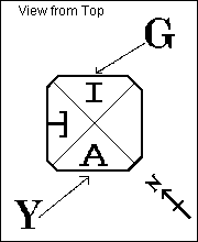 Further to Stone No 8: we found the stone on Shepherd’s Rigg near a clearing in the wood after following the wall from the Wyndygate road. It is set in a stone wall about two feet high, and is similar in shape to No 4. It has markings on the top. These markings we find inexplicable: they looked like an elaborate T on the west face and an A on the south face. There is an I on the north side. The stone is in very good condition. [The stone actually lies NE/SW. The markings were somewhat overgrown with moss when I examined the stone in November 2000, and a small tree had fallen on top of it so that the SW quadrant of the top was obscured. A sketch of the markings is shown to the right. Gill Smith.]
Further search may reveal other stones.
Forward to the last Fairfaxes; back to the Lord
Emleys; return to Contents.
